GOLDEN LISTINGS TEST
Placer · 40 acres
Somewhere, OR · Sierra County · California
"A new claim full of gold!"
Mountain Man Mining™ · Featured Listing
Overview
This is the full description.
History
Active 1890-1960.Geology
Quartz veinMining District Research
Sierra County, California occupies one of the most mineralized corridors in the entire Sierra Nevada range, sitting astride the legendary Mother Lode belt and its northern extensions. The claim falls within Township 12N, Range 25E, a region historically tied to the broader Alleghany and Downieville mining districts of Sierra County — two of California's most productive gold-producing districts. The Alleghany district alone yielded tens of millions of dollars in gold during its peak years, with high-grade narrow vein deposits famously worked at the Original Sixteen to One Mine producing specimen-grade gold well into the twentieth century. The Downieville district, centered along the North Yuba River drainage, was active from the early 1850s through the mid-twentieth century and contributed substantially to California's overall gold output through both lode and placer methods.
The regional geology of Sierra County is dominated by Jurassic and Cretaceous-age metamorphic and metavolcanic rocks of the Foothills belt, intruded by granitic bodies of the Sierra Nevada Batholith. Gold mineralization in this corridor is predominantly mesothermal in character, associated with quartz veins emplaced along regional shear zones and fault structures cutting through greenschist-facies metasedimentary and metavolcanic host rocks. The presence of quartz veining noted on this claim is entirely consistent with the structural and lithological setting known to host economic gold concentrations throughout Sierra County. Placer deposits in the area are genetically linked to the erosion of these primary lode sources, with bench gravels and streambed placers representing reworked Tertiary and modern alluvial material.
The mining history of this portion of Sierra County reflects a sustained period of activity stretching from the Gold Rush era through the mid-twentieth century, consistent with the 1890–1960 active period recorded for this claim. Early hydraulic and drift mining gave way to hard rock methods as surface gravels were exhausted, and the two adits recorded on this property suggest organized underground exploration targeting the quartz vein system at depth. Nearby past production indicates the district was not marginal — sustained investment in underground development across this timeframe typically reflects encouraging gold values sufficient to justify ongoing work.
For modern prospectors and small-scale operators, this 40-acre placer claim presents a compelling combination of documented geological structure, verified historical workings, and practical field accessibility. The existing adits provide immediate insight into subsurface vein character and orientation, while nearby water access supports both traditional placer recovery and any prospecting or sampling programs. Dirt road access keeps entry costs manageable. Sierra County continues to attract serious prospectors precisely because its geological endowment is well-established, its records are well-documented, and surface and near-surface gold values remain recoverable using modern small-scale equipment. A property with active workings history through 1960 and a quartz vein structure in this county warrants careful evaluation.
Production
Past production nearbyAt a Glance
Claim Details
GOLDEN LISTINGS TEST — Main Features
| Type of Claim | Placer; |
| Size | 40 acres |
| Commodities | |
| Accessibility | Dirt Road |
| Closest City | Somewhere, OR |
| Camping | Yes |
| Cell Reception | |
| Deposit Type | Placer |
| Development Status | |
| District | Sierra |
| Township / Range | T12N R25E |
| BLM Office | |
| Elevation |
Technical Data
Economic & Geologic Information
Economic Information
| Operation Type | Placer |
| Development Status | |
| Commodity Type | |
| Deposit Size |
Mining District
| District Name | |
| Nearby Mines (MRDS) |
Geologic Structure
Assay & Survey Documents
Transfer Process
Mineral Rights Transfer
A mining claim gives the holder the right to mine on mineral-rich land belonging to the federal government. Claims can be bought, sold, leased, gifted, willed, or used as collateral — transferred in part or in entirety, just like any other real property.
Transfer Method: · Mineral Rights: · Surface Rights: · Lien Status:
Contact us anytime with questions about the transfer process. All fees and assessment paperwork are current and paid through .
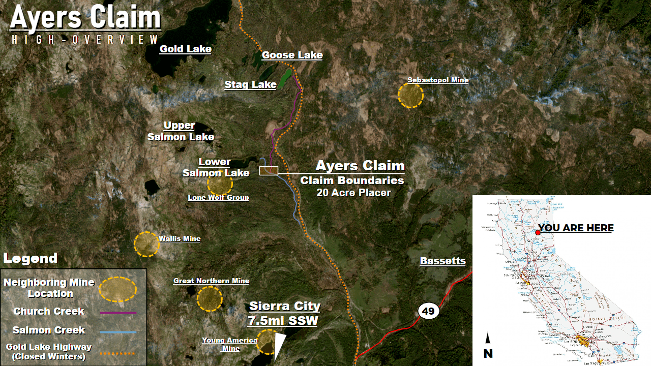
Boundaries & Location
Claim Boundaries & GPS Coordinates
NE: , | NW: ,
SE: , | SW: ,
Millsite Boundaries
NE: , | NW: ,
SE: , | SW: ,
Center Pin: 35.788829, -114.922604
Open in Google Maps → Download KMZ →
Photography
GOLDEN LISTINGS TEST — Photographs

")
")
")


Purchase
Purchasing "GOLDEN LISTINGS TEST"
Have questions? Want to see the mine in person? Ready to make an offer? We respond to all serious inquiries promptly.