 New
Lode
New
Lode
The Virginia Lynn
📍 Dolores County, Colorado
- Ag
- Au
- Cu
- Pb
- Zn
- Mo
- PGE
$1,000,000
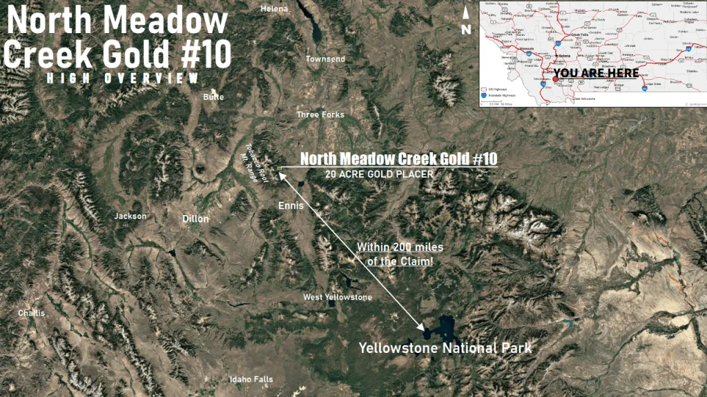
20 Acre Placer Mining Claim · Tobacco Root Mountains · Madison County, Montana
$16,500
All BLM & county filing fees included. 10-day transfer guaranteed.
Unpatented Montana Gold Claim
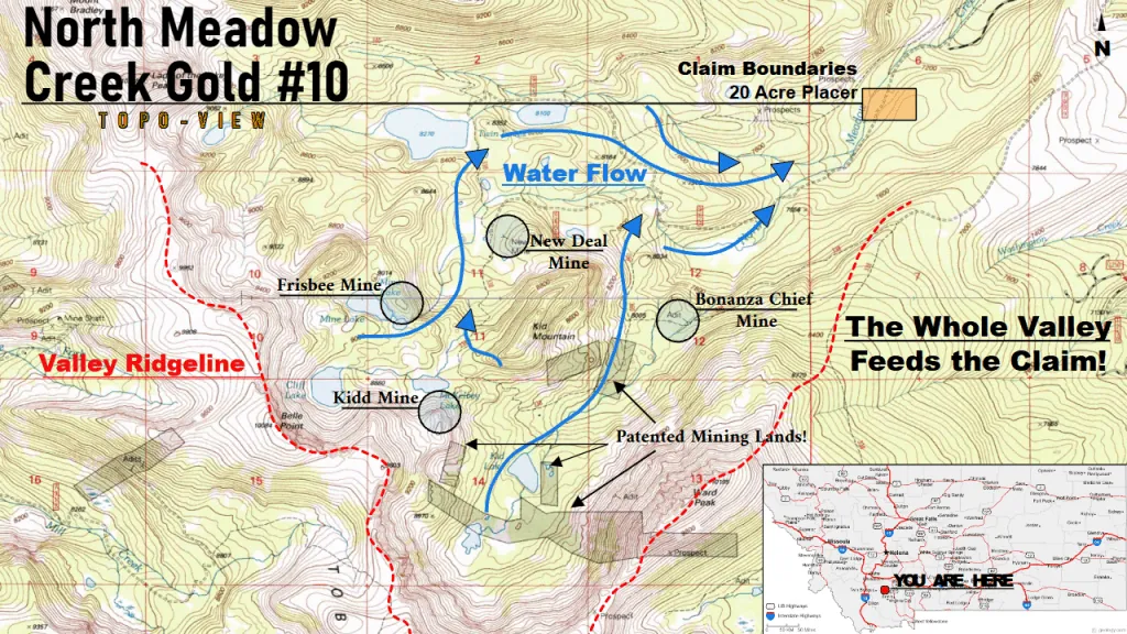
Two hour’s drive from Yellowstone National Park, the North Meadow Creek (NMC) Gold #10 claim is found capturing all the gold in the valley leading up to the foot of the beautiful Tobacco Root Mountains! Downstream from past producers like the Kidd Mine with high-grade gold and silver ores, this mountain river placer profits from the natural erosion of an entire mountain’s worth of minerals down into its river waters!
Capturing the rain and snow run-off from mountains where the Kidd Mine, the Frisbee Mine, and the New Deal Mine all sit, the North Meadow Creek Gold #10 claim captures all the treasures further up the mountain! From the Kidd Mountain flows native gold and silver, but also copper-rich and colorful “peacock ore” bornite, and the fiery-orange “ruby blend” sphalerite. Once the gold-laden ores flow past the NMC Gold #10 claim, they continue nearly 12.5 miles downstream onto patented placer grounds like the Cibola VIII and the North Meadow Creek Placers, before they finally tumble and become lost to the depths of Ennis Lake. The NMC Gold #10 acts as the gateway between what comes down the mountain and what’ll be left to fall downstream!
The NMC Gold #10 is the Southern sister claim to the North Meadow Creek Gold #9; Capturing the gold before its Northern sibling claim, this claim holds natural advantages…
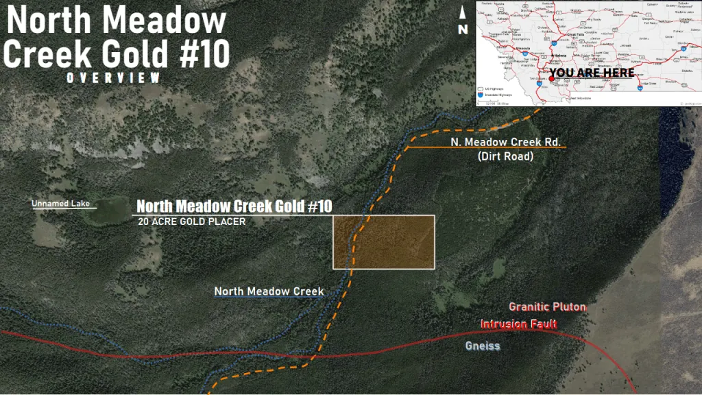
Below the surface, the NMC Gold #10 finds itself just downstream of several large granitic and gneissic contact zones the Kidd and other mines in the local valley benefit from. With the North Meadow Creek cutting through the valley right on a main fault between the two major geologic formations, the river could easily pick-up unseen minerals from veins hiding under and around the river itself!
But if the gold isn’t easy coming some days, there’s plenty to do around the NMC Gold #10 claim. Trout are known to be in the river and local lakes. Hiking and camping near and around the claim is a popular activity for many visitors to the Tobacco Root Mountains, and there are plenty of good, tucked-away spots to camp on the claim itself!
Accessibility isn’t an issue on this claim. Minus the need to have a vehicle that can handle well-maintained dirt roads, the North Meadow Creek is mere feet from the road. Because of dense vegetation in spots closest to the river, it is recommended to clear a path for equipment larger than your hands and pans.
If you’re interested in purchasing this unpatented Montana gold claim, please email me here.
| Type of Claim | Unpatented Placer; MT106322280 |
|---|---|
| Size of Claim | 20 ACRES |
| Mining Commodities | Gold, Silver, Gems |
| Accessibility | Well-Maintained Dirt Roads |
| Closest City | Ennis, Montana |
| Camping | Yes. Up to 14 days at a time |
| Prior Workings | None |
| Cell Phone Reception | Some Bars on AT&T Networks |
| Type of Deposit | Placer |
| NE | 45.514164°, -111.896291° |
|---|---|
| NW | 45.514173°, -111.901341° |
| SE | 45.512360°, -111.896291° |
| SW | 45.512342°, -111.901403° |
| Monument | 45.513278°, -111.901167° |
|---|
Corner and monument coordinates (WGS84) read from the claim’s official Google Earth KMZ boundary file.
| Operation type | Placer |
|---|---|
| Development status | Prospect |
| Commodity type | Gold, Silver, Gems |
| Deposit size | Unknown |
| District Name | Washington (Meadow Creek) Mining District, Madison County |
|---|---|
| Deposit MAS/MILS ID |
Kidd Mine – MRDS #10019414 New Deal Mine – MRDS #10010533 Frisbee Mine – MRDS #10245918 |
| Type of Structure | Granitic |
|---|---|
| Structure Description |
(MAJOR) – Granitic Rock Igneous > Plutonic > Granitic |
A mining claim gives the holder the right to mine on mineral-rich land that belongs to the federal government. Mining claims are a tangible asset and show proof of all interests in minerals in the area. They can be bought, sold or used as collateral, just like any other piece of real estate.
A mining claim can be sold, traded, leased, gifted, willed, used as collateral or transferred in part or in its entirety just like any other real property using a quitclaim deed which is a recordable conveyance. Questions about the transfer process can be answered by contacting us anytime. All fees and paperwork current and assessment fees are paid through Sept. 1st 2026.
$16,500
Cash Price
Make a one time payment and get new mineral rights transferred in your name quick and easy.
Buy Online NowHave questions? Concerns? Make an offer on the North Meadow Creek Gold #10.
After your purchase is complete you will be requested to fill out our new claim owner form with your name/address or add any additional claimants you want on the claim.
You’ll get digital copies of your COL and Map of Location in to your claim(s) will be delivered via email via PDF format as well as Google Earth™ KMZ map file with your claims discovery, corners and points of interest.
We handle all the filing and transfer services on your behalf. Expect to get official stamped/recorded copies of your paperwork mailed to you from the Madison County Recorder’s Office and the Montana Bureau of Land Management officiating you as the new claimant within 45 days of purchase. Then officially enjoy mining gold on your own land!
North Meadow Creek Gold #10 is a 20 acre placer mining claim located in the legendary Tobacco Root Mountains of Madison County, Montana. The Tobacco Roots are one of Montana’s most mineralized mountain ranges, with a rich history of gold, silver, and gemstone production dating back to the 1860s.
Primary and secondary commodities on this claim include:
The Tobacco Root Mountains are underlain by Precambrian metamorphic and igneous rocks that have been intruded by numerous granitic bodies. These intrusions created extensive hydrothermal alteration and mineralization throughout the range. The placer deposits along North Meadow Creek contain gold and silver that have been eroded from upstream lode sources, along with a variety of gemstones including garnet and sapphire that are found in the creek gravels.
The North Meadow Creek Gold #10 claim is situated in one of Montana’s most prolific mining regions. The claim area is characterized by:
The 20-acre footprint provides ample creek frontage for sampling and small-scale placer operations. The claim’s location in the Tobacco Root Mountains offers not only mineral potential but also stunning natural beauty and abundant wildlife.
The Tobacco Root Mountains have been an important center of mining activity in Montana since the 1860s. The range is home to numerous historic mining districts including Virginia City, Nevada City, and Pony, all of which produced significant quantities of gold and silver. The district’s geology is complex, with Precambrian metamorphic rocks intruded by Cretaceous granites that host extensive vein and replacement deposits.
Placer deposits throughout the Tobacco Roots have yielded gold for over 150 years, and modern prospectors continue to find color in the creeks and gulches of the range. The presence of gemstones including garnet, sapphire, and quartz crystals adds to the recreational and economic potential of claims in this district.
North Meadow Creek Gold #10 sits within this proven mineralized watershed, offering both immediate placer potential and the opportunity to discover new pay streaks along the creek.
Satellite view of the claim area. Click the pin for a quick summary.
Approximate district-level location shown to protect the exact claim boundaries. Contact us for precise coordinates and a guided map.
Explore other active lode and placer claims.