North Meadow Creek
📍 Montana
$16,500
20 Acre Unpatented Placer Claim · Klamath District · California, Siskiyou County
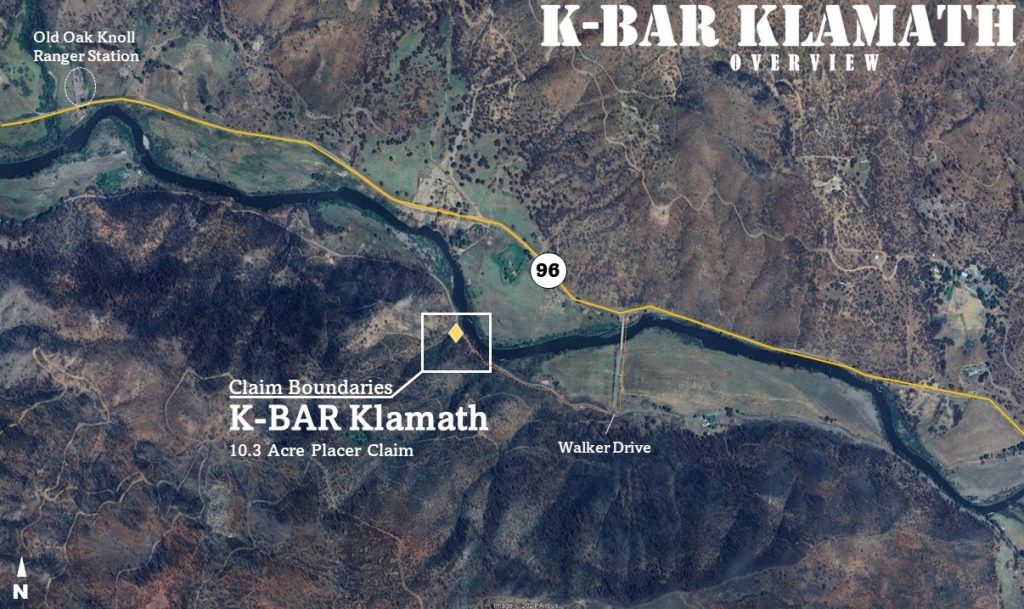
K-Bar Klamath was a 10.3-acre unpatented placer claim on a bend of the Klamath River in Siskiyou County, California, a past-producing area and one of the few stretches of the river still open to public panning.
Type of Claim: Unpatented Placer Claim
Size of Claim: 10.3 Acres
Mining Commodities: Gold, Silver
Past Production: Yes
State/County: California, Siskiyou County
Accessibility: Paved & partly paved roads
Deposit Type: Sands and gravels
Cell Phone Reception: Spotty 4G LTE, all networks
Discovery Marker (GPS): 41.836913°, -122.871184°
The K-Bar Klamath 10.3-acre gold placer harvested from the mighty Klamath River in Siskiyou County, California. A small claim made along a bend on the Klamath River, K-Bar was one of the very few areas along the river still available for the public to pan for gold and join the new California gold rush — following in the footsteps of the New 49ers.
The recent fires that rolled through California weakened a lot of the top soil and exposed new ores and gravels finding their way into the Klamath River. Everything to the East fell into the river and passed through this peaceful bend; treasures delivered by the Humbug and Little Humbug Creeks, Vesa and Grouse Creeks — creeks known to produce nuggets as large as an ounce — passed through here. The river ran strong all year long, cold-tolerant panners could work it even in winter.
Access from the Klamath River Highway was easy, with a rough gravel road even closer from the South. A small sandbar on the South bank provided a staging ground next to the river in late summer. The claim covered the river bank to bank at a smooth bend with plenty of river frontage, catching gold falling in from the East. It sat about 20 miles outside Yreka, 40 miles outside Mt. Shasta, and 60 miles outside Grants Pass.
Economic Profile: Surface-placer operation, inactive development status, gold/silver commodity type. Ore body type: undivided pre-Cenozoic metavolcanic rocks and Condrey Mountain schist. Mining District: Siskiyou.
MRDS References: Mineral Resource Data System reports for the Ascondry and Siskiyou Klondike Placer occurrences.
We list new claims weekly. Browse our current inventory or get notified when claims matching your criteria become available.
Browse Active Listings Get NotifiedThis claim has sold, but these active listings are available right now: