The Historical Record
Seventy Years of Federal Paper on Copper Gulch — From a 1952 Location Certificate to a 1986 Finding of Discovery
This is the part most listings don’t bother showing you.
Every mining claim says it’s promising. Very few can hand you seventy years of dated paperwork to back it up — location certificates, U.S. Forest Service mineral examinations, Bureau of Mines correspondence, and lab assays running from a 1973 smelter settlement to a 2023 XRF spectrometer report. The Virginia Lynn can. What follows is that paper trail, in order, with the documents themselves shown alongside the story they tell. Page 3 has the full numbers if you want to skip straight to the assays — this page is the story of how they got there.
The First Claim on Copper Gulch
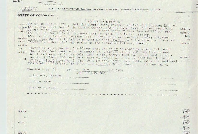
The oldest document in the file is a Colorado lode location certificate dated July 15, 1952. Three men — Louie S. Thorton, Harry Bash, and Charles H. Bash — staked fifteen hundred by six hundred feet on Copper Gulch, a tributary of the West Dolores River, in what the certificate calls the Lone Cone Mining District. The certificate was recorded as location No. 59983, page 238 of the county record. They named it the West Dolores Copper claim, and noted it joined the southwest side of another claim already on the ground. That predecessor claim isn’t the Virginia Lynn by name — the ground it describes sits in the same drainage the Virginia Lynn now covers, and it’s the earliest hard evidence that someone was staking copper ground on this exact gulch before Eisenhower’s first term was over.
Little Silver Takes Its Name
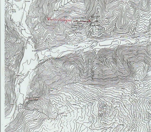
Fifteen years later, on August 31, 1967, the ground was relocated as Little Silver No. 1, No. 2, and No. 3 — the name the claim carried for the next fifty-plus years, and the name that fills nearly every page of the federal file that follows. BLM would eventually assign the three claims serial numbers C-MC 114955, 114956, and 114957. Two more claims, Silver Syndicates Sister and Silver Syndicate, were added to the group in 1988. The hand-marked topographic map below, pulled from the claim file, shows the Little Silver ground sitting on the West Dolores River near Deer Creek and the old Miller Ranch — the same terrain description that runs through every examination that follows.
The Forest Service Takes Notice
By 1973 the claimants wanted to haul ore, and that meant the San Juan National Forest had to decide whether the ground actually justified a road. The Forest Supervisor’s office wrote to Rocky Mountain Regional Office that September requesting mineral examinations on Little Silver and three related Teaser claims, noting the claimants were “anxious to begin ore removal operations” but that road access crossed National Forest land the claim didn’t cover.
Mineral examiner Warren C. Roberts walked the ground on October 1, 1973, and his memo doesn’t hedge: “The deposit is copper mineralization in sandstone of the Triassic Dolores Formation. Gray and black copper minerals with secondary azurite and malachite are visible through a vertical distance of six feet and a horizontal distance of 20 feet exposed in the face of an open cut.” The claimant had already shipped ore — mill receipts from the Inspiration Consolidated Copper Company smelter at Globe, Arizona showed “net returns from $25 to $54 per ton with the values being copper, gold and silver, in order of dollar value,” and Roberts noted trucking to Globe ran $17.40 a ton, less than the combined cost of trucking and freight to a railroad.
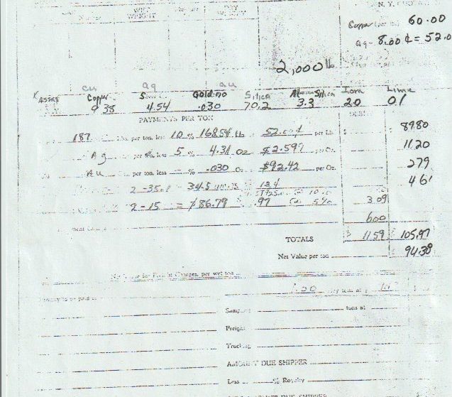
One of those actual smelter settlement sheets survives in the file — dated August 31, 1973, from Inspiration’s smelting department, for a shipment out of the Little Silver Mine. After copper, silver, and gold payments and the standard smelter deductions, the net value came to $94.38 a ton. That’s not a geologist’s estimate or a grab-sample headline — it’s what a working smelter actually paid for ore that came out of this ground, in 1973 dollars.
A Second Generation, A Second Look
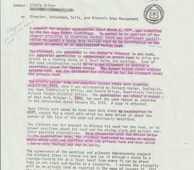
By 1977 the claim had passed to the next generation — the Forest Service file records that the claimant “succeeded to his father’s interest in the lode” and had requested permission to rebuild an access road the old alignment could no longer support. Roberts, now signing as a geologist rather than a mineral examiner, returned to the ground on August 19, 1977, accompanied by geologist Richard Hepler and supervisory forester Ronald Wilcox, for what he called “almost a repeat” of his 1973 visit. His finding, dated January 26, 1978, closes with a single sentence that carries real legal weight in mining law: “My observations, and the prior evaluation of smelter receipts, lead me to the opinion that a discovery within the meaning of the mining laws exists within the limits of the Little Silver lode mining claim.”
That phrase — discovery within the meaning of the mining laws — is not casual language. It’s the specific legal standard a claim has to clear to be valid at all, and by 1978 a federal geologist had gone on record twice saying this one clears it.

Independent Labs Confirm It
The federal examiners weren’t the only ones testing this ground. In September 1981, John C. Kephart & Co.’s Grand Junction Laboratories ran a sample submitted from Little Silver, Dolores: 7.00% copper and 2.71 oz/ton silver, no measurable gold. Five years later, in March 1986, the Colorado Assaying Company in Denver ran a full spectrographic analysis on a sample from Del Oro Mining, submitted from the Little Silver Mine. It came back at 10% copper and 3.70 oz/ton silver, with the assayer’s own remarks worth quoting in full:
“This sample consists mostly of the light gray fine-grain Siltstone, which is a compacted mixture of grains of near white Feldspars, Quartz Sand, some fine flake Mica, a little soft white Limestone, some pale greenish complex iron silicate mineral, etc. The copper is present mostly as the heavy metallic black Chalcocite (copper and sulphur) and a little dark green Malachite (copper carbonate). The Copper and Silver contents are of commercial interest & value.”
Ed Phillips, The Colorado Assaying Company, spectrographic analysis, March 19, 1986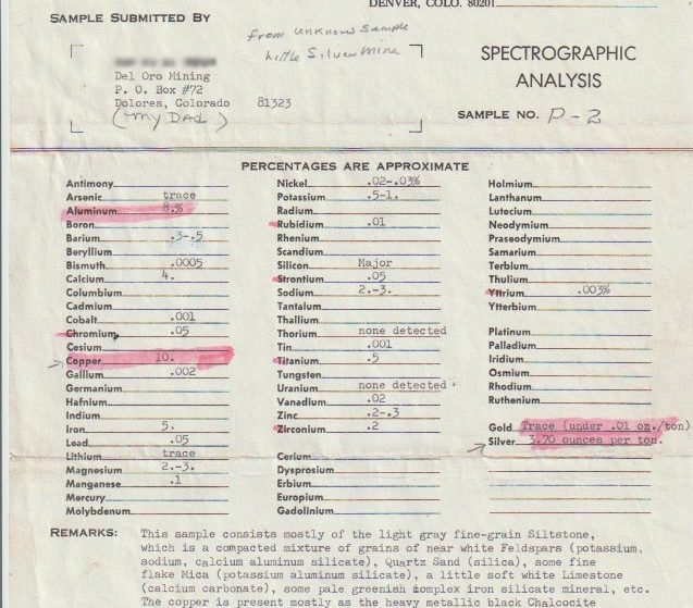
The Full Federal Mineral Report
The centerpiece of the file is a formal, twelve-page “Mineral Report — Little Silver Mine,” prepared for the Dolores Ranger District, San Juan National Forest. Two Forest Service examiners, Frederick Mullin and Andrew Raby, walked the ground with Craig Yancy and Michael Spencer of the Dolores Ranger District on June 11–14, 1986, with the claimant present the entire time. What they documented is the most complete technical picture of this mine on record.
Getting There
The report’s own directions still work today almost exactly as written: north from Dolores, Colorado on Highway 145 for 13.5 miles, then Forest Road 535 for 14 miles to an access road marked by a mailbox labeled “Little Silver Mine,” then a final 0.5 miles to the claim. Highway 145 is paved; the rest is forest road.
What’s Already Built
The southernmost claim in the group has an access road and a small pole corral — the claimants kept horses and a mule on site for prospecting work. The northernmost claim has a log cabin, roughly 30 by 30 feet, with an unfinished 20-by-20 log addition, plus a parking and turnaround area. The middle claim holds the mine itself: an access road to the portal, a turnaround, a lower portal with its own dump, the caved-but-visible “discovery hole” where the claimants say they first entered the mine, a prospect pit, an outhouse, a storage shed, a generator, and a small tractor-loader. The report notes the family worked the mine “with the help of their children.”
Underground
At the time of the 1986 examination, about 98 feet of tunnel were accessible on the upper level — an adit, one crosscut, and one drift — with an estimated further 70 feet caved but visible beyond the crosscut. A lower level exists but was caved and inaccessible at the time; air movement between the caved sections and the open adit told the examiners the two levels connect somewhere underground, even though no one could walk between them. The portal and first six feet of the adit are timbered; the rest is unsupported and, in the report’s words, “in fair to poor condition,” with active drips and seeps and heavy fracturing along the back and ribs. That’s the honest state of a hand-worked mine that’s sat idle between visits — not a finished operation, but real, mapped, accessible workings all the same.
The Rock Itself
A two-foot-wide breccia dike cuts through the crosscut, part of a twenty-foot-wide fault zone at the portal. Surface exposures at the portal and at the “discovery hole” are stained red with hematite and carry malachite and azurite in masses several inches thick — good enough, the examiners noted, to be a source of specimen material on its own. One piece of mineralized sandstone “rapidly yielded molten metal when heated with a welding torch,” described as self-fluxing because of its high silica content and purity, and a smelter return ticket in the file showed no penalties for refractory minerals. A few specimens were tentatively identified as ruby silver and cinnabar — a panned sample of crushed sandstone from the mine dump contained tiny flecks that may have been native mercury, though not enough was recovered to confirm it. The coaly layers within the sandstone carry chalcocite, bornite, malachite, and azurite as replacement nuggets up to two inches across, some of which the claimant had already sold to mineral dealers.
The examiners placed the workings right at the geologic contact between the Dolores Formation and the Entrada Sandstone — a boundary in a local stratigraphic column that, top to bottom, also includes the Morrison Formation (its Brushy Basin and Salt Wash members), the Junction Creek Sandstone, the Wanakah Formation, and the Cutler Formation. Mineralization is structure-controlled: hydrothermal fluids moved along faults and into the sandstone, precipitating native copper and copper sulfides in the rock’s pore spaces and along thin coaly interbeds, with later groundwater oxidizing much of it into the malachite and azurite you see today. And then there’s this line, which the report doesn’t dwell on but doesn’t walk back either: “Some evidence exists that this mine was opened and worked long before the historic beginning of mining at Rico and much of southwest Colorado, at least prior to the middle 1800’s.”
How Big Is It, Really?
The 1986 report includes one piece of professional judgment beyond the sample table — the examiners’ own field estimate of how far the mineralized structure might extend, based on outcrop and the underground workings rather than any drilling: “several hundred yards along the fault zone, several tens of yards in width, and tens to hundreds of yards vertically.” That’s a geologist’s read on the size of a structure, not a resource estimate, and we’re not presenting it as one — nobody has drilled this ground to confirm it. But it’s the scale a modern exploration program would actually be testing.
The same report is also specific about what this deposit is not. It describes a breccia-hosted, structurally controlled system — copper carried by hydrothermal fluids moving along a fault into porous sandstone — and states plainly that “the Little Silver mineralization is not similar to the Rico deposits,” the porphyry-associated veins and replacement ore that built the historic district a few miles east. Genetically, these are two different ore-forming systems that happen to sit in the same mountain range. We’d rather tell you that than let the neighborhood do the talking.
The Assays
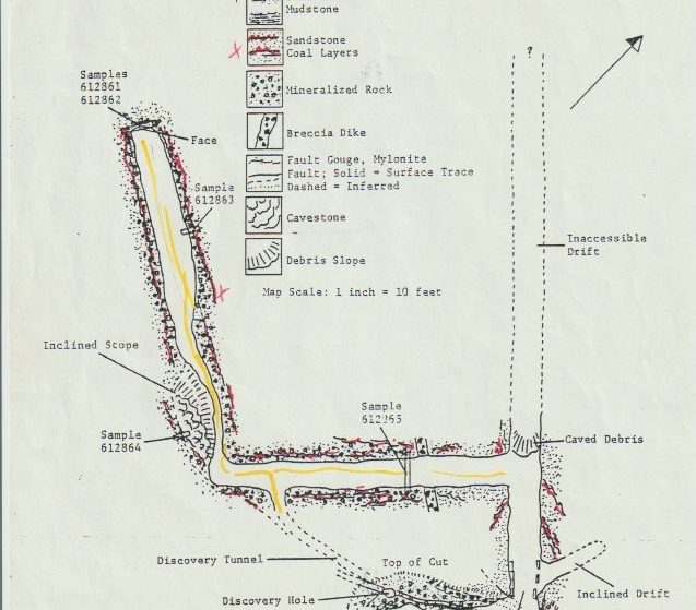
Six samples were cut directly from the mine workings and sent to Skyline Labs Inc. for assay. The results:
| Sample | Type | Rock | Cu % | Ag oz/ton |
|---|---|---|---|---|
| 612861 | Horiz. Channel, 4′ | Sandstone/coal sequence | 3.60 | 1.10 |
| 612862 | Horiz. Channel, 3′ | Sandstone/coal sequence | 0.16 | trace |
| 612863 | Vert. Channel, 4′ | Coaly layers | 3.40 | 1.49 |
| 612864 | Spot sample | Fault gouge | 0.34 | trace |
| 612865 | Chip Channel, 13′ | Sandstone/coal sequence | 1.25 | 0.11 |
| 612866 | Vert. Chip, 5′ | Sandstone/coal sequence | 3.95 | 0.43 |
Assays by Skyline Labs Inc., 1986, on behalf of the USDA Forest Service. Full lab report in Appendix 5 of the source document (linked below). Sample 612864 is flagged in the source report as not representative of a mining width — it was cut from a thin clay/mylonite fault-gouge layer that had been partly mined out, not the ore-bearing sandstone.
About 180 feet of tunnel were visible on the upper level at the time, with the caved lower workings and the airflow between them suggesting a comparable extent below. The report’s own economic read on a single accessible ore block — roughly 200 cubic yards projected between the crosscut and drift — used a representative grade of 3% Cu and 1.1 oz/ton Ag against 1986 metal prices of 60¢ copper and $5.00 silver, and came out to about $17,500 in place, or roughly $67 a cubic yard. Metal prices have moved a great deal since 1986; we’re showing you the period math as the examiners wrote it, not restating it in today’s dollars.
The Conclusion
“Observable geologic features, sampling and assay results, proximity to past producing mines, and favorable geologic conditions described in this report all indicate that the land included in the Little Silver #1 lode mining claim contains mineral values which would render their extraction profitable and which would justify expenditures to that end.”
Andrew G. Raby, Pagosa Ranger District, signed May 21, 1987 — technical review and approval by Frederick B. Mullin, Rocky Mountain Regional Office, USDA Forest Service, signed August 22, 1988The report’s formal conclusion follows the same line: “the lands are considered mineral in character.” That’s about as close as the federal government gets to putting its name behind a claim.
The Neighbors, and No Conflicts With Them
The 1986 Mineral Report’s status record also lists the claims immediately adjoining Little Silver, for anyone doing their own title homework: Copper Gulch Nos. 1 through 5 (BLM serials C-MC 138489–138493, located May 23, 1974, with no assessment-work record on file at the time of the report) and Cortez No. 1 (BLM serial C-MC 210578, located March 13, 1985). The report notes no conflict of location between any of these claims and the Little Silver group — the kind of boring, clean boundary language a buyer actually wants to see in a seventy-year-old claim file.
The Bureau of Mines Weighs In
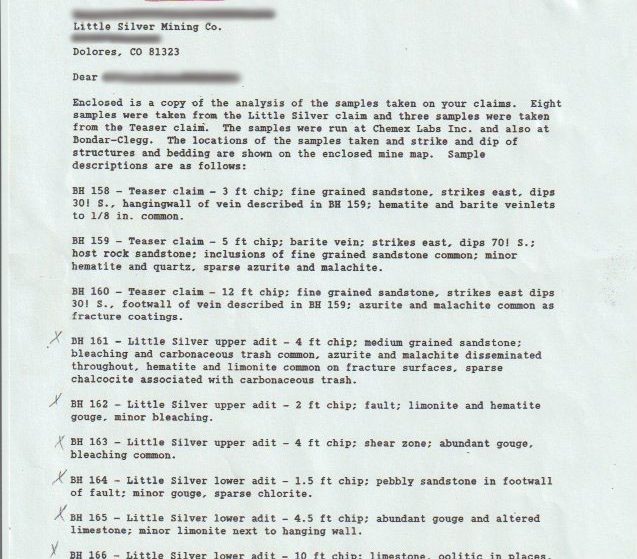
A February 1990 letter from the U.S. Bureau of Mines’ Denver field office to “Little Silver Mining Co.” in Dolores enclosed the results of eleven more samples — eight from the Little Silver claim, three from the adjoining Teaser claim — run at both Chemex Labs and Bondar-Clegg. Geologist Brian J. Hannigan’s sample-by-sample descriptions read like a field notebook: hematite and barite veinlets in the Teaser claim’s hanging wall, azurite and malachite disseminated through bleached sandstone in the Little Silver upper adit, chalcocite associated with carbonaceous trash, oolitic limestone with calcite veinlets in the lower adit. Two samples ran high enough that they exceeded the labs’ own upper detection limits — sample BH159 for barium at Bondar-Clegg, and samples BH160 and BH161 for copper at Chemex Labs — meaning the true grade in those spots was higher than standard assay could even measure, and had to be rerun.

The Paper Trail, Made Official
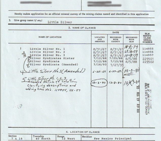
By August 1993, the Bureau of Land Management had an amended survey application on file listing the full claim history under the group name “Little Silver”: Little Silver No. 1, 2, and 3 (located and recorded 1967, BLM serials 114955–114957), Silver Syndicates Sister and Silver Syndicate (located 1988, BLM serials 229501–229502), plus amended notices in 1969 and 1980 clarifying the legal descriptions. The claims sit in Sections 7 and 18, Township 40 North, Range 12 West, New Mexico Principal Meridian, Dolores County, San Juan National Forest — the same section and township you’ll find on the Virginia Lynn’s current corner coordinates on Page 1.
What This Means For You
None of this makes the Virginia Lynn a producing mine today — it isn’t one, and we’re not going to tell you otherwise. What it does mean is that you’re not buying a claim on a hunch. Four separate federal examinations across seventeen years, three independent commercial labs, and one working smelter all looked at this same ground and came back with the same story: real copper-silver mineralization, hand-sortable specimen quality, and — in a federal geologist’s own words — a discovery within the meaning of the mining laws. The workings are old and they need work before anyone runs equipment through them again. But the paperwork saying it’s worth doing that work has been sitting in a federal file since 1988, and now it’s sitting in yours.
Page 3 has the full lab numbers, including the 2023 Reed Laboratories assays that pushed the copper values into the 20s and 30s percent. Or if you’ve seen enough, the price and the contact information are one click back on Page 1.
All Active Claims at a Glance
Every claim currently for sale, sorted by price. Tap a name to open the full listing.
| Claim | Price | Commodity | County / State | Acreage |
|---|---|---|---|---|
| The Virginia Lynn you’re here | $1,000,000 | Silver, Gold, Copper +4 | Dolores County, Colorado | 87.64 |
| The Sedona Legend & Sunrise Claims | $71,980 | Gold | Yavapai County, Arizona | 80 |
| Mountain View Tungsten Project | $65,000 | Tungsten, Copper | Lyon County, Nevada | ~140 |
| Ophy I-V Claims | $41,250 | Gold, Silver, Copper | Boise County, Idaho | 79.35 |
| Sunny Side Up #1-2 | $21,500 | Gold, Silver | Southeast Fairbanks, Alaska | 80 |
| Boulder #2 & #3 | $15,000 | Gold, Silver | Boise County, Idaho | 41.32 |
| The Winna-Winner Claims | $10,000 | Gold, Silver, Iron +2 | Humboldt County, Nevada | 40 |
| Belcher Canyon | $9,997 | Gold | Nye County, Nevada | 20 |
| The Golden Trinity Claim | $8,000 | Gold, Platinum, Silver | Trinity County, California | 20 |
| Marigold #1 | $7,500 | Gold, Silver | Yavapai County, Arizona | 20 |
| Ayers Claim | $6,500 | Gold, Silver | Sierra County, California | 20 |
| The Eureka Comstock Placer | $5,000 | Gold, Copper, Silver | Washoe County, Nevada | 20 |
Prices and availability change as claims sell. Ask about any of these or see what has already sold.